

SALT LAKE CITY — The snowstorm that arrived Thursday is packing a more powerful punch Friday morning, causing a stream of accidents and delays across Utah.
Below you will find the latest information from the state:
FRIDAY
3:00 p.m.
The Winter Weather Advisory along the Wasatch Front, and the Winter Storm Warning in the mountains have been canceled.
11:00 a.m.
Major Jeff Nighbur with the Utah Highway Patrol joined FOX 13 to discuss the current condition of roadways in Utah, reporting that UHP responded to 140 accidents Friday morning.
10:20 a.m
The Salt Lake City office of the National Weather Service sent out snow totals for Utah, and it looks like great news for skiers, snowboarders and the local resorts.

CLICK HERE for complete snowfall results.
—————————————————————-
10:15 a.m.
Southbound lanes on I-15 at 14200 South have reopened after a lengthy delay due to accidents and icy conditions.
—————————————————————-
9:55 a.m.
From the Utah Avalanche Center:
- Salt Lake area mountains - The avalanche danger is CONSIDERABLE on mid and upper elevation aspects facing northwest through east where storm snow and fresh wind drifts are sitting on top of weak snow underneath. Human-triggered avalanches are likely and natural avalanches are possible. There is a MODERATE danger on mid and upper elevation slopes facing west through south and southeast where avalanches involving storm snow and wind-drifted snow are possible. Low elevations have a Low danger as there currently isn't enough snow coverage.
—————————————————————-
9:22 a.m.
Utah Highway Patrol officials say they have responded to approximately 76 accidents between midnight and 9 a.m.
—————————————————————-
9:00 a.m.
The Utah Department of Transportation is asking drivers to delay travel up to 3 hours, if possible, due to the snow.
—————————————————————-
8:54 a.m.
Brighton Ski Resort is celebrating the snowfall, having received 21 inches in the past 24 hours. Even better at Eagle Point Resort which has received 28 inches.
We’ve received 21” in the past 24 hours! We now have a 46” base and counting ❄️
— BrightonResort (@BrightonResort) December 10, 2021
Please note we do not allow for overnight parking, please take your car with you when you leave the resort. pic.twitter.com/z48759fSep
—————————————————————-
8:40 a.m.
Chains are required for all semi trucks traveling westbound on 1-80 through Parley's Canyon.
—————————————————————-
8:00 a.m.
FOX 13 meteorologist Dan Pope is in the Weather Beast and gives a great look at conditions on northern Utah roadways.
—————————————————————-
7:55 a.m.
Despite the snow, Salt Lake City School District schools are open and will start on time.
Salt Lake City School District schools are open and starting on time this morning. We realize road conditions may differ throughout the city. Please exercise caution as you travel this morning. Our schools will not penalize students for arriving late. #SLCschools #uted pic.twitter.com/Rz1oAdetmP
— SLC School District (@slcschools) December 10, 2021
———————————————————————————————————-
THURSDAY
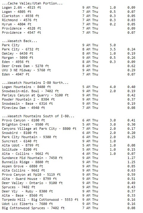
10:15 a.m.
Check out the snow totals (second column from right) from 6 p.m. Wednesday through 10 a.m. Thursday.
—————————————————————-
10:05 a.m.
The National Weather Service confirms that Salt Lake City is seeing its first measurable snowfall in 259 days, the city's fourth longest streak with no snow.
Salt Lake City now has the first measurable snowfall (0.1" or more) this season! It has been 259 days since the last accumulating snow, which is the 4th longest streak with no snow. It's the 5th latest snow of the season on record. #utwx pic.twitter.com/BoOdv8NrCk
— NWS Salt Lake City (@NWSSaltLakeCity) December 9, 2021
—————————————————————-
9:50 a.m.
What's the rest of the day look like, and how much more snow on Friday? FOX 13s Damon Yauney has the rest of today's forecast and a look ahead.
—————————————————————-
9:15 a.m.
Snowbird ski resort reports it has received 7 inches of snow over the last 24 hours. Great news for the areas that need it.
—————————————————————-
8:15 a.m.
Slick conditions from this morning's storm caused a school bus to roll over in Morgan with a student on board.
—————————————————————-
7:39 a.m.
Rocky Mountain Power reports an outage in West Valley City affecting 2,402 customers. Power is estimated to be repaired by 10:30 a.m.

—————————————————————-
7:10 a.m.
From the Utah Avalanche Center:
- Salt Lake area mountains - The danger will rise to MODERATE on all upper elevation slopes and mid-elevation NW, N, NE, and E facing slopes where today’s new snow may produce some long-running sluffs, and possibly some soft slab avalanches where the new snow rests on old, weak faceted snow.
- Ogden area mountains - The danger will rise to MODERATE on upper elevation NW, N, NE, and E facing slopes where today’s new snow may produce some long-running sluffs, and possibly some soft slab avalanches where the new snow rests on old, weak faceted snow.
- Provo area mountains - The danger will rise to MODERATE on all upper elevation slopes and mid-elevation NW, N, NE, and E facing slopes where today’s new snow may produce some long-running sluffs, and possibly some soft slab avalanches where the new snow rests on old, weak faceted snow.
—————————————————————-
6:50 a.m.
FOX 13s Damon Yauney has an updated timeline for the storm and what residents should expect the rest of the day.
—————————————————————-
6:55 a.m.
Since 5 AM snow has become heavy over the northern Utah mountains with rates up to 2"/hr. Valleys have started as rain, but we're starting to see a change to snow from around Ogden northward. Watch for deteriorating road conditions this morning. #utwx #wywx pic.twitter.com/lDesaeCru6
— NWS Salt Lake City (@NWSSaltLakeCity) December 9, 2021
—————————————————————-
6:30 a.m.
🚨 #RoadWeatherAlert 🚨
— UDOT Cottonwood Canyons (@UDOTcottonwoods) December 9, 2021
The #TractionLaw is now in effect for both Big & Little Cottonwood Canyons. #SR190 #SR210 @UDOTTRAFFIC @UDOTRegionTwo @AltaCentral @AltaSkiArea @SnowbirdAlerts @SolitudeMTN @BrightonResort @UPDSL @BrightonUT @alta_of pic.twitter.com/qzzmNkSr8y
—————————————————————-
Friday - 4:30 p.m.
DUGWAY SCHOOLS ONLY- Students/staff at Dugway Schools will not attend in-person & will move to online learning due to incoming winter weather conditions. All other schools in TCSD are expected to be on a normal schedule.
— Tooele Schools (@tooeleschools) December 8, 2021
