


SALT LAKE CITY — The heavy winds that were forecast to dominate the weather across northern Utah began reaching their peak Thursday evening, with damage seen to homes in many neighborhoods.
TRACK THE STORM: Get real-time storm information by downloading the FREE Utah Weather Authority app
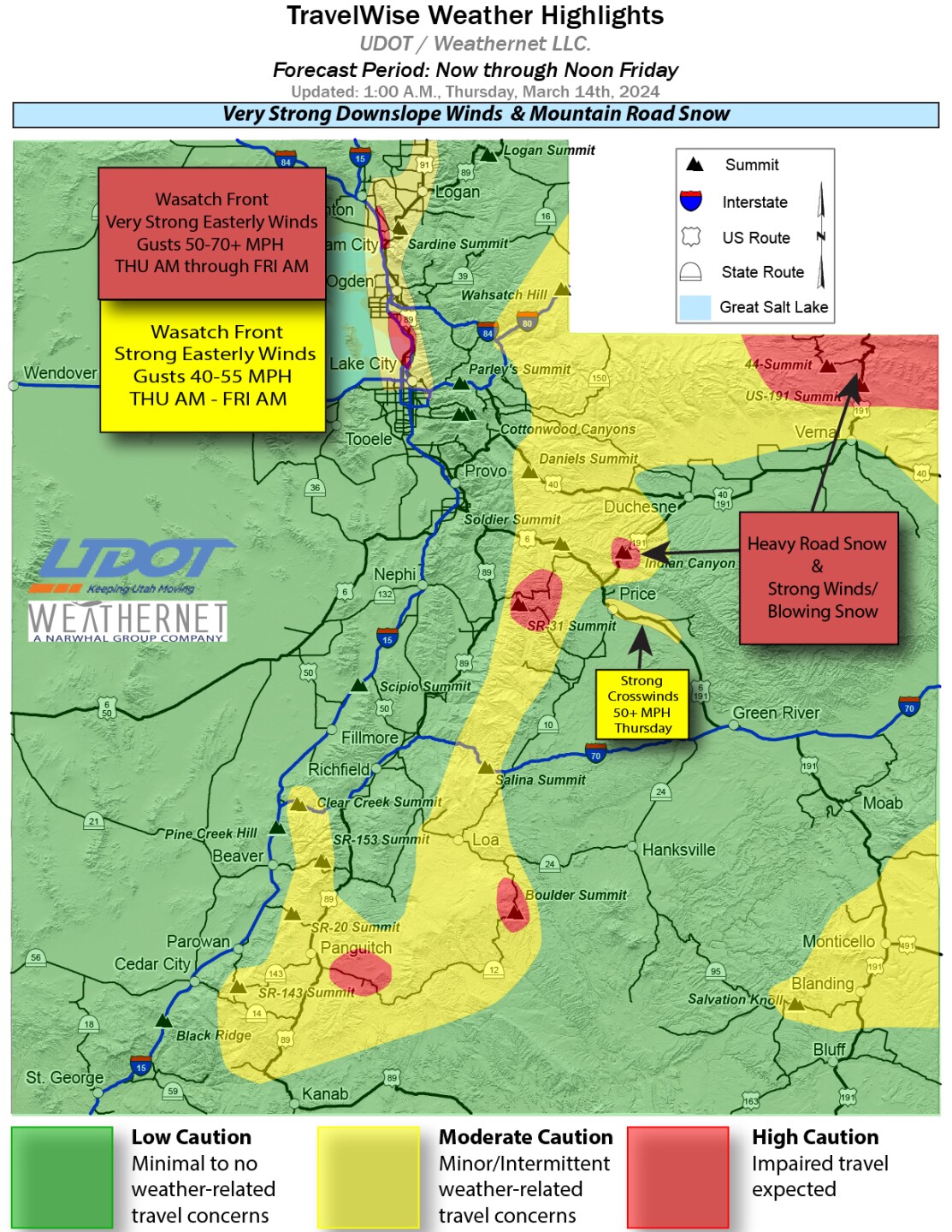
The strongest winds along the Wasatch Front are being found between Ogden and Bountiful, but downslope winds are also impacting the benches of the northern part of the Salt Lake Valley, along with eastern Box Elder County and Cache County.
Peak winds arrived at approximately 9 p.m. and while they have sporadically died down every so often, they will continue through 9 a.m. Friday.

As of 10 p.m., winds were gusting at 52 miles per hour in Ogden, with Brigham City seeing gusts of 31 mph. Some areas saw much higher wind speeds, with the following wind gusts having been recorded:
- Logan Peak - 76 mph
- Layton - 60 mph
- US-89 at Weber River - 56 mph
PHOTOS: Amazing photographs of clouds rolling into northern Utah

Residents are being advised to secure anything that could blow away such as trash cans, home decorations and trampolines. The wind could also down tree branches that could cause power outages.
The Utah Department of Transportation issued a "Road Weather Alert" early Thursday, hours before dangerous winds are expected to move into the northern Utah area during mid-morning.
According to UDOT, the following routes will experience weather-related travel concerns during the forecast period:
- I-15, Tremonton to North Salt Lake; high concern Brigham City and Centerville/Farmington area
- I-80, Through Salt Lake Valley; Echo Jct to WY border
- I-84, Mouth of Weber Canyon
- I-70, Clear Creek/Fish Creek Summits; Salina Summit
- US-89, Through Cache valley and south to Centerville; Panguitch to Mt Carmel Jct
- US-191, WY border to north of Vernal; Duchesne to Price (Indian Canyon); SR-46 Junction to North of Monticello
- US-40, Daniels Canyon to west of Duchesne
- US-6, Spanish Fork Canyon to Green River
- SR-31, Entire route
- SR-35, Near Wolf Creek Pass
- SR-20, Summit
- SR-143, Summit
- SR-153, Summit
- SR-14, Summit
- SR-150, Near closure gate
- SR-12, Entire route
- SR-44, Entire route
In southern Utah, snow is forecast to continue through Saturday afternoon, with up to 12 inches expected at Capitol Reef National Park and Bryce Canyon National Park. The southern mountain ranges could receive 12-24 inches, with up to four feet around Boulder Mountain.

