SALT LAKE CITY — Dozens of car crashes, including one where a driver died, and a late-start day for some schools were a result of an intense winter storm that swept through Utah Monday and Tuesday.
New snow totals show Fruit Heights saw about 9.2 inches of snow from the storm, while Clearfield, Sandy and North Salt Lake saw about seven inches.
Utah's mountains received even more powder, with Powder Mountain getting about 19 inches of snow and Brighton seeing about 18 inches.
Snowbird reported that they received 14 inches of new snow in the last 24 hours. Deer Valley reported 10 inches of powder Tuesday, which also happens to be their opening day for the season.
The storm brought the statewide snow water equivalent average to 153% of the median. That average does not account for all of the snow that fell Tuesday morning, the National Weather Service explained.

Utah Highway Patrol said on Monday night, just before 8 p.m., a Dodge 2500 pickup truck was traveling East on SR-40 when the driver lost control due to weather.
Blowing wind and iced-over roads made for dangerous terrain and near milepost 138, the 43-year-old female driver ran off the road and the vehicle rolled multiple times, UHP reported.
A 47-year-old male passenger was pinned as a result of the crash and both of the individuals were taken to the hospital.
Officials said they were later notified the female driver had died of her injuries. They note both occupants appeared to be wearing seatbelts and no impairment is suspected.
On Tuesday morning, due to the weather, the Davis School District announced a two-hour late start for all schools.
"High schools will start at 9:30 a.m., junior highs at 10:10 and elementary schools at 10:50. All district school busses will be on a two-hour delay," the district announced. "All kindergarten and preschool classes are cancelled today, including all Head Start/Early Head Start and Title I preschool programs. Additionally, all before-school programs and field trips scheduled to begin prior to the late-start time are cancelled."
Other school districts such as Alpine, Canyons, Salt Lake, Granite and Ogden, all announced their classes would start as normal but that if students were late because of the weather, their tardiness would not be marked.
A winter storm warning was put in place for the Salt Lake valley and the Wasatch Mountains south of I-80 until 2 p.m. Tuesday. In addition, Cache Valley added a winter weather advisory for snow and a cold front.
Details on warnings, advisories and other National Weather Service alerts can be found here.
Heavy snow and a cold front dropped overall temperatures on Monday night, making it so snow that fell Tuesday morning stuck easily to surfaces, including roads.
A lake effect band hit parts of Utah Tuesday morning, making for even more treacherous conditions in Davis, Weber, Salt Lake and Utah counties.
INTERACTIVE RADAR: Click here to track the storm as it moves across Utah
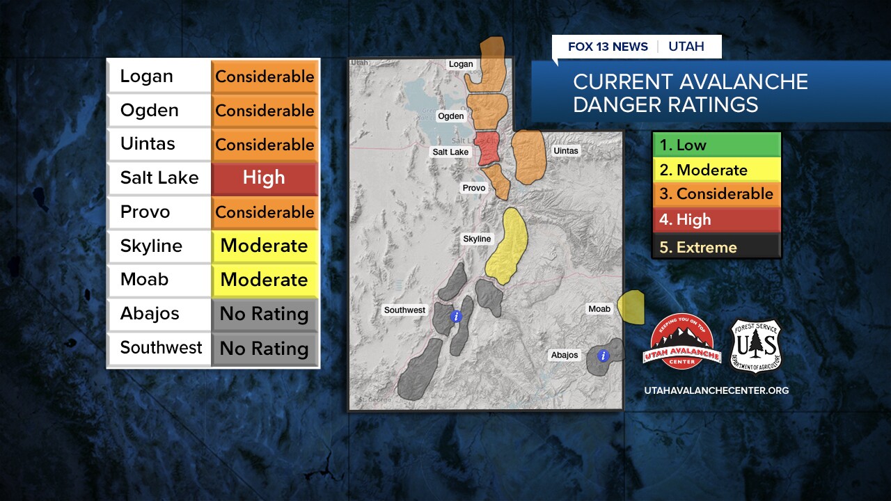
With the snow, the Utah Avalanche Center warned avalanche danger is at the "high" level Tuesday and likely to happen even at low to mid-elevations.

Due to the snow, the Utah Department of Transportation said road conditions were slick across the state, causing a lot of havoc for commuters.
As of 6 a.m. Tuesday, Utah Highway Patrol reported that troopers had responded to 170 crashes.
The Salt Lake City Police Department reported they had responded to "several" weather-related crashes by Tuesday morning, pleading with drivers to slow down on the roads.
While responding to a crash that involved at least three cars, SLCPD said a police car was hit. No injuries were reported in that incident.
TRACK THE STORM: Get real-time storm information by downloading the FREE Utah Weather Authority app

Utah's Weather Authority is tracking the storm and says the heaviest snow will hit Utah from 3 to 8 p.m. on Monday before a slight lull. Then the snow picks back up again for the Tuesday morning commute.


