


SALT LAKE CITY — The Utah State Legislature's Redistricting Committee is beginning to draw maps.
Data from the 2020 U.S. Census was finally received and is being plugged into software for members of the committee to start the process to draw boundaries for congress, legislature and state school board.
FOX 13 News 360: A look at Utah's redistricting process
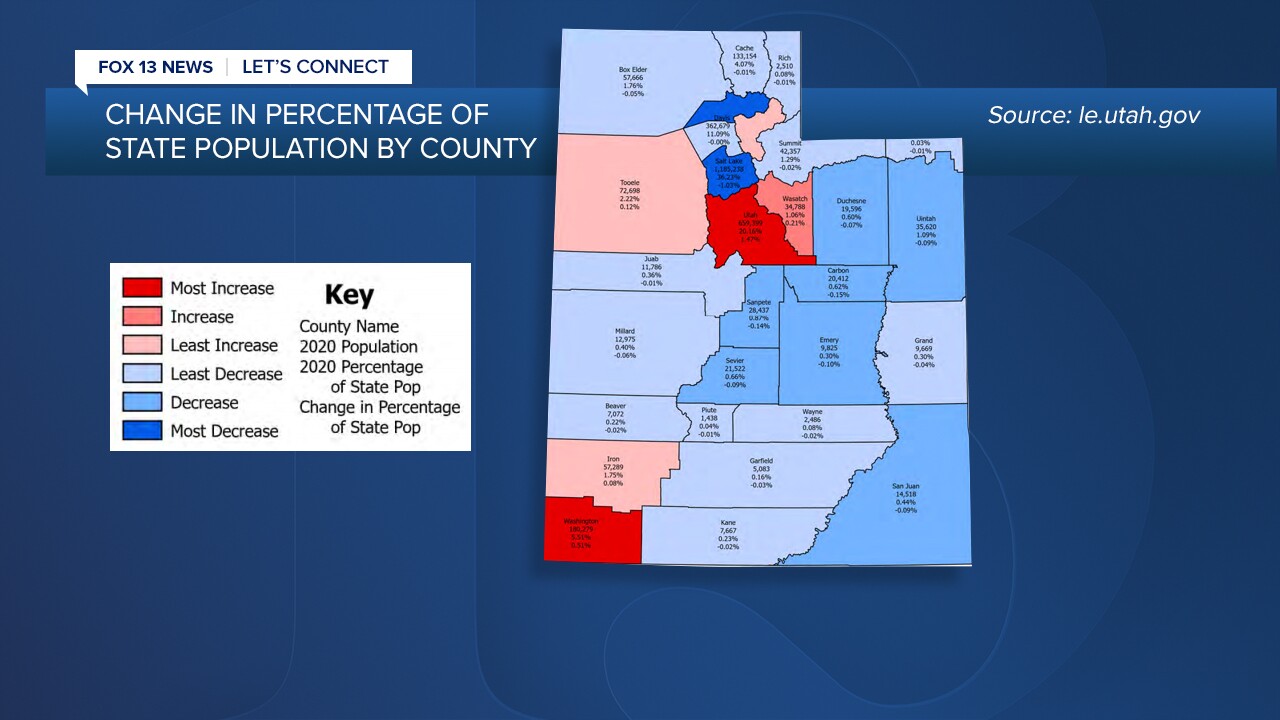
The census information also highlighted some significant shifts in population. For example, there have been sizable growth recorded in Utah and Washington counties, while there was also population declines in Weber, Davis and northern Salt Lake County (the southern end of that county saw population increases).
"My area shrunk a little bit and I’m not surprised," said Rep. Sandra Hollins, D-Salt Lake City, who sits on the legislature's redistricting committee. "At one time, the district I represent used to be the place where people come for affordable housing and for starter homes. But what I’m hearing from individuals is they’re no longer able to afford to live in my district, so as a result they’re moving out."
The population shifts will impact where political boundaries ultimately land. The legislature's committee must have the districts represent a fairly-equal population. For rural districts, that often means one representative for multiple counties. For urban districts, it can mean a lawmaker for a much smaller — but more populated — area.
"As we start doing maps, that ripple effect is going to have a lot to say even in northern Utah," said committee co-chair Rep. Paul Ray, R-Clinton. "What happens just because of that Salt Lake-Utah County area being so large."
The legislature's redistricting committee is different from the independent redistricting commission that voters approved when they passed Proposition 4 in 2018. The independent commission has already been meeting to collect input from the public, encouraging them to draw maps and submit feedback.
But it's the legislature's redistricting committee that will have the final say on any maps. The committee's co-chairs have both publicly said they would love to approve maps from both the public and the independent commission.
"People draw maps, and bring those to our outreach sessions and explain why they drew that map that way," said committee co-chair Sen. Scott Sandall, R-Tremonton.
But Sen. Sandall said anyone who starts to draw a map, but do it for the entire state. You can't just draw your own district and leave it at that.
Stuart Hepworth, a University of Utah student, attended Monday's commission meeting and presented five different maps he had crafted.
"I’m hopeful that the public will be able to bring maps, that the legislature will be able to adopt maps proposed by the public, these that prioritize keeping communities of interest together," he told FOX 13.
