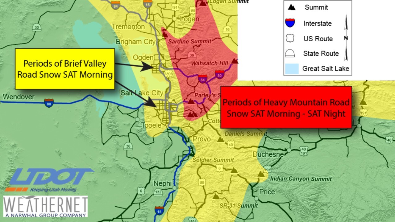
SALT LAKE CITY — A weekend storm is expected to create hazardous driving conditions in parts of northern Utah starting late Friday and lasting through Saturday.
“If the roads get bad enough, you really want to slow it down,” said UHP Trooper Kristin Brown, who has been patrolling I-15 and I-215 for the last few weeks. “Be wearing your seatbelt at all times, weather conditions especially when you’re crashing into other people we don’t want to see ejections things like that it’s going to turn into a bigger accident than it needs to be.”
LIVE RADAR: Check out FOX 13s Interactive Radar to see the weather in your neighborhood
The storm is expected to bring snow to much of the area, including central Utah. Early snow in Salt Lake County will cause roads to turn wet.
All mountain routes north of I-70 and adjacent to I-15 down to Brian Head will see periods or road snow with this system, the Utah Department of Transportation advised.
HOURLY FORECAST: Here's the upcoming forecast for Utah
Northern mountain routes will see road snow late Friday through Saturday night, with snowfall heavy at times Saturday morning. The central and southern mountain routes will see road snow beginning after noon on Saturday before later in the day.
Drivers heading up the canyon and mountain roads should be prepared for chain advisories.
UHP responded to hundreds of crashes, accidents, and slide-offs within the past week on major interstates. Trooper Brown is one of UHP’s newest troopers but has been out-and-about during recent snowstorms.
“We want everyone to be safe out there, we want everyone to be able to get from point A to point B,” said Trooper Brown. “If the roads are really bad and it’s not something that’s urgent that you need to be out on the road doing, just hang out, hang at home for a little bit and just wait it out, wait the storm out that you’re safe, we’re not responding and having to deal with anything bad and just take care of yourself.”
UDOT has had an extremely busy week with avalanche mitigation in Big and Little Cottonwood Canyon, however, there’s been an increasing trend on interstates that road crews have noticed.
“One of the things we’re seeing out there on the roads is a lot of aggressive driving, people tailgating and not giving themselves room to break in case of poor weather or they need to stop fast,” UDOT Spokesperson John Gleason told FOX 13.
As was the case Friday after Little Cottonwood Canyon was closed for nearly three days, UDOT is predicting a ‘run on the canyons’ this weekend with all the fresh snow.
“If we have to close down the canyons, restrict travel I should say, it’s probably going to be due to the number of people that are getting up there to try to experience the fresh powder, I mean everybody wants to be up there right now and for several days that just wasn’t possible because the canyon was closed,” said Gleason.
In years past, Gleason admits that Cottonwoods traffic was a little bit more predictable than what they’ve seen in the 2020-2021 winter season.
“It’s not as predictable as it’s been in the past and a year like this, yeah we know we’re going to see a lot of skiers and snowboarders up there but there are a lot of people wanting to get out and sled and hike and climb and just really enjoy the outdoors and I think year after year we’re seeing more of a trend of people going out to the canyons and so, I think it’s just growing in popularity.”
Some of the mountain traffic can likely be attributed to COVID-19 and the surge in outdoor activity.
UDOT also tracks road fatalities and has seen an encouraging trend in the winter months with less deaths on Utah roads. Gleason said there is a spike in the summer months, with people typically driving faster during more favorable weather conditions.


