SALT LAKE CITY — Parts of Utah, including Salt Lake City, are seeing severe weather Tuesday as a cold front arrives, bringing thunderstorms and the potential for flash floods. The National Weather Service said the threat for flooding has increased throughout the day.
FOX 13 WEATHER APP: Download the FREE FOX 13 First Alert Weather app
A Severe Thunderstorm Warning was issued for the Salt Lake area until 6:15 p.m. with quarter-sized hail possible, along with wind gusts up to 70 miles per hour.
"This storm has a history of wind gusts over 60 mph. This warning includes Layton, Salt Lake City, West Valley City and other cities in between. Take cover now in the warned area," the NWS warned on social media.
Video below shows heavy rain hitting the Midvale area
Afternoon thunderstorms in southern Utah have already produced winds up to 51 miles per hour near the Fish Springs Wildlife Refuge in Dugway, the NWS reported. Winds up to 70 miles per hour were expected with a storm included in a Severe Thunderstorm Warning near Low and Timpie. Golf ball sized hail was reported in the area of a Severe Thunderstorm Warning issued for the Fillmore, Kanosh and Meadow area that expired at 5:45 p.m.
Video below shows hail in Sandy as severe weather moved through Salt Lake area
In Garfield County, the NWS reported ping pong ball sized hall along with 60 mile per hour winds southeast of Boulder.

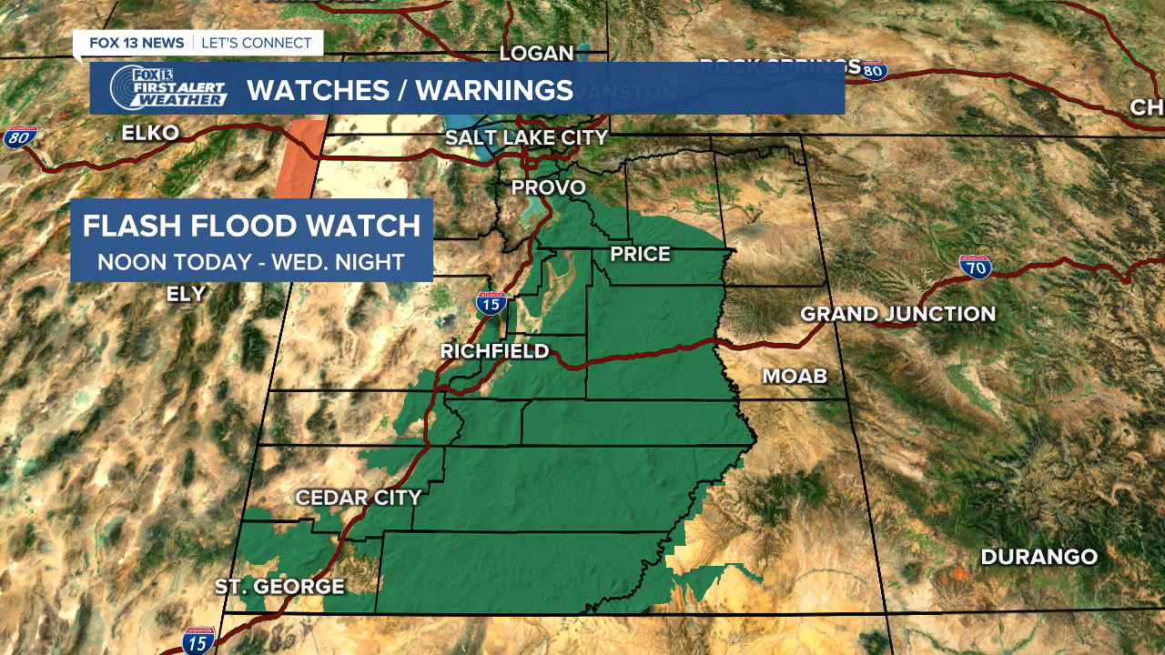
A Flash Flood Watch (lower level than a Warning) was also issued for portions of southern and central Utah, all the way up to Salt Lake County. Slot Canyons in the south and burn scars in the central area of the state are at the highest risk of flash flooding.
Duchesne County experienced some flash flooding, as seen in this video:
Wow.
— 𝐁𝐫𝐢𝐚𝐧 𝐒𝐜𝐡𝐧𝐞𝐞 (@brian_schnee) August 18, 2021
Some parts of the state got some serious 🌧 downpours today.
Take a look at the flash flooding outside of Duchense on Sowers Canyon Road! #utwx | @fox13 | @AllisonCroghan
🎥 Serena Hoffman pic.twitter.com/yCMI4nz0Hc
The National Weather Service says burn scars located above highways and residential areas are at risk in northern Utah.
A Flash Flood Warning remains in place for part of Kane and San Juan counties until midnight.
Flash Flood Warning including Kane County, UT, San Juan County, UT until 12:00 AM MDT pic.twitter.com/4a9syLhtxU
— NWS Salt Lake City (@NWSSaltLakeCity) August 18, 2021
Down in Emery and Wayne counties, a Flash Flood Warning was issued until 7:30 p.m. with authorities asking residents to move to higher ground immediately. The warning included numerous slot canyons, with weather officials warning "Get to a safe place now!"
Another Flash Flood Warning was issued for an area containing Big Water and Wahweap that expired at 9 p.m. Another was in place for Garfield County until 8 p.m.
Cooler temperatures and more rain are forecast for Wednesday after the cold front moves through. The chances of precipitation will remain in the forecast for much of Utah through Monday.
When we mentioned a pattern change, we really meant it! Here is the precipitation forecast through next Monday morning. That's a good bit of rain for Utah!
— NWS Salt Lake City (@NWSSaltLakeCity) August 16, 2021
More details this afternoon! #utwx pic.twitter.com/4vHUAuldmO
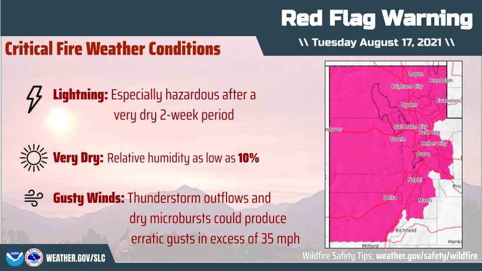
Following weeks of an extremely dry period, a Red Flag Warning ending at 9 p.m. has the potential to create critical fire weather conditions, according to the National Weather Service. Gusty winds up to 35 miles per hour and the possibility of thunderstorm outflows will exist.
READ: Parleys Canyon Fire evacuees allowed to return home after rain helps containment efforts