Weather

Actions

Showers to the east herald a cooldown

Saturday Morning Weekend Forecast
Posted
Graphics from the FOX 13 Weather Center showing the forecast for the Utah State Fair on Saturday and Sunday. Saturday shows a high of 78° with 20% chance of showers and thunderstorms. Sunday shows Sunny weather with a high of 83°.

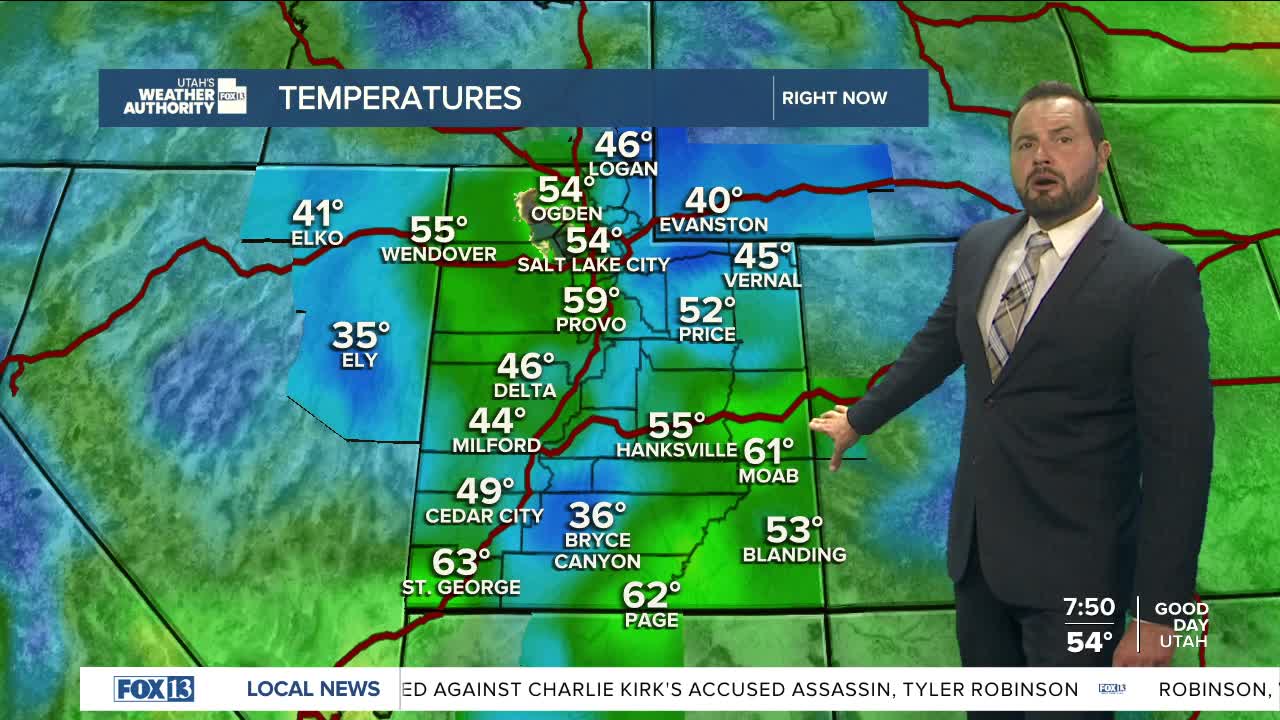
It’s a picture-perfect start to the weekend along the Wasatch Front, with sunshine greeting much of northern Utah. But head east, and the story looks very different.

Graphics from the FOX 13 Weather Center showing the Severe Weather Outlook. Most of the storm activity hangs on the eastern part of the state, over into Colorado.

Showers and thunderstorms are already bubbling up in Emery and Grand counties, signaling a more active day ahead for the eastern half of the state as a trough of low pressure swings through.

Graphics from the FOX 13 Weather Center showing predicted storm activity. Much of it is shown on Central and Eastern Utah, particularly over Moab, Price, and near Vernal.

Some of these storms could pack a punch. Grand and San Juan counties are under the greatest threat, where isolated severe storms could deliver wind gusts over 58 miles per hour and large hail. The most active window will be late morning through the afternoon.

Graphics from the FOX 13 Weather Center showing the chances of rain in the Salt Lake Valley. It's expected to rise to 15% by 1PM, then to 25% by 3PM before dropping back down to zero by 6PM.

Along the Wasatch Front, storm chances are lower, but not zero — the best shot for showers will be east of I-15 and south of Salt Lake County. Temperatures statewide will trend cooler than normal, running about five degrees below average for this time of year.

By Sunday, conditions start to settle down. High pressure builds in, clearing out the storms and helping temperatures climb back to near seasonal averages across Utah. That quieter pattern doesn’t last long, though.

Early next week, another quick-moving clipper system will dip into northern Utah, bringing a small cool-down and a chance for a few mountain storms. After that, warm and dry weather is expected to take hold through midweek.

Graphics from the FOX 13 Weather Center showing the predicted high temperatures for Utah. From Top to Bottom, Left to Right: Ogden 78°, Logan 76°, Elko 77°, Wendover 81°, Salt Lake City 78°, Evanston 68°, Park City 67°, Vernal 65°, Ely 74°, Delta 80°, Provo 77°, Price 68°, Milford 80°, Cedar City 77°, Richfield 77°,  Moab 79°, St. George 89°, Kanab 82°, Bullfrog 84°, Blanding 72°.

REAL-TIME WEATHER: Get the latest weather forecasts by downloading the FREE Utah Weather Authority app