

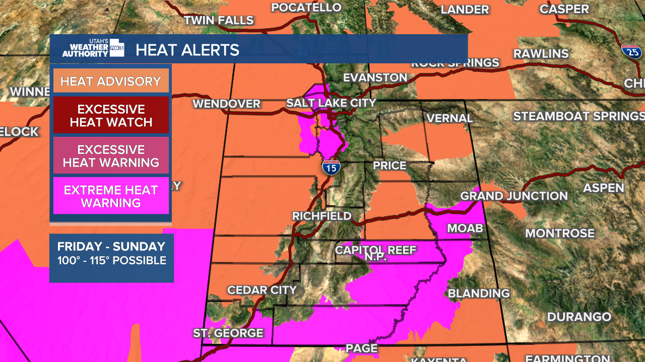


SALT LAKE CITY — Dangerously hot conditions will descend upon nearly all of Utah over the weekend, with Extreme Heat Warnings issued across the state and heightened concerns about public safety and health.
Temperatures well over 100 degrees Fahrenheit are forecast throughout the Salt Lake Valley, the Wasatch Front and most other parts of northern Utah, with a high of 105 degrees expected on Saturday. The Extreme Heat Warning for the valley will go into effect at noon Saturday and last until 9 p.m. Sunday.
"Drink plenty of fluids, stay in an air-conditioned room, stay out of the sun, and check up on relatives and neighbors," the National Weather Service warned.
Madi Baggett explains the symptoms of heat illness to look out for below:
Residents and visitors should limit outdoor activities to the early morning and evening, although overnight low temperatures are only expected to drop to the mid-70s
"Take action when you see symptoms of heat exhaustion and heat stroke," the NWS added. "Anyone overcome by heat should be moved to a cool and shaded location."
In anticipation of scorching temperatures in northern Utah, Salt Lake County will offer extended hours at its recreation centers on Sunday.
- Northwest Recreation Center - 1255 Clark Avenue (300 N), Salt Lake City
Sun: 10:30 am – 8:00 pm (Cool Zone only 2:30 – 8:00 pm) - Taylorsville Recreation Center - 4948 South 2700 West, Taylorsville
Sun: 9:00 am – 8:00 pm (Cool Zone only 3:00 – 8:00 pm) - JL Sorenson Recreation Center - 5350 West Herriman Main Street, Herriman
Sun: 10:00 am – 8:00 pm (Cool Zone only 3:00 – 8:00 pm) - Dimple Dell Recreation Center - 10670 South 1000 East, Sandy
Sun: 10:00 am – 8:00 pm (Cool Zone only 3:00 – 8:00 pm) - SLC Sports Complex - 645 South Guardsman Way, Salt Lake City
Sun: 10:00 am – 8:00 pm (Cool Zone only 5:00 – 8:00 pm)
Extreme Heat Warnings went into effect at noon Friday for parts of Washington and Garfield counties, as well as Zion National Park and Capitol Reef National Park, as temperatures are expected to hit 112 degrees Fahrenheit over the weekend.

While temperatures rise, humidity levels are forecast to drop, which will create hazardous fire conditions, especially if gusty winds pick up.
Conditions will improve slightly on Sunday evening when a weak cold front moves through, but the "cool down" will be short-lived as temperatures creep upwards again starting on Tuesday.
