

Utah’s snowpack is taking a significant hit at one of the worst possible times of the year.
With the state’s typical peak just days away — around April 2 — conditions around the state are terrible, to say the least. Snow that would normally blanket the mountains this time of year is sparse, following a month of record-breaking warmth that sent snowpack levels into a sharp decline.
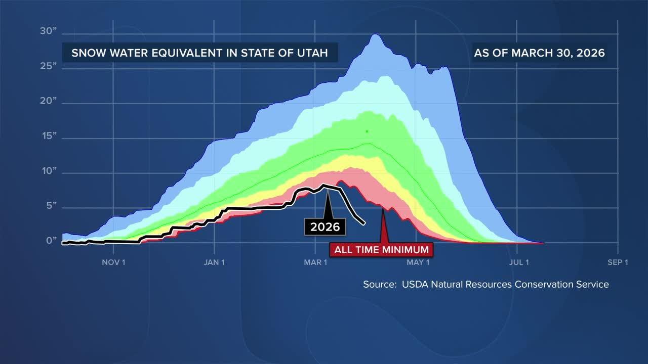
Statewide, the numbers paint an even more concerning picture.
“We're at 19% of that number today,” said Jon Meyer, the assistant state climatologist at the Utah Climate Center. “We'll probably be closer to 15% of that number on the actual day of our usual normal peak.”
But it’s not just how low the snowpack is — it’s how quickly it dropped.
Meyer said watching the collapse unfold in real time has been striking.
“To actually watch it play out was just surreal… to see us get into uncharted territory for record amounts of low snow water and then to just continue to plummet that number so far out of the statistical reality that we've had for 45 years of observations,” he said.
WATCH: Utah fire officials warn of drier-than-usual conditions ahead of wildfire season
In northern Utah, mountain ranges around Cache Valley are already looking more like early summer than early spring. Typically, snow would still stretch far down the mountainsides. Instead, patches of green are already taking over.
And while some individual areas may not be at record lows, the statewide picture is bleak.
“When we add all 180 weather stations together, it's just collectively bad everywhere,” Meyer said.
That rapid melt is now raising concerns about what happens next — especially when it comes to water supply.
“The warm temperatures brought down a lot of what there was, and so concerns that maybe we have already peaked for stream runoff for this time of year is hard to fathom,” Meyer said. “That should be coming 6 to 8 weeks down the road from now.”
If that proves true, it could mean significantly less water flowing into reservoirs during the critical spring runoff season. Meyer says some of the first impacts will likely be felt in agricultural communities, with water restrictions potentially expanding across the state.
“This year, there will be areas that see some meaningful impacts,” he said. “I would imagine that we're going to see lots of water restrictions and regulations beginning to creep across the state's populations this year.”
With spring just getting started, how water is used now could make a difference in the months ahead.
“People are turning on their sprinklers… this is a time when we should not be spending what little stream flow and reservoir recharge we have on keeping our spring grass super lush,” Meyer said. “Pumping the brakes as long as we can in terms of water use… is going to be really critical.”
There is still hope that additional storms could provide some relief, but experts say it won’t be enough to fully recover from such a dramatic deficit.
“Every drop, every flake counts… but we're so far behind that it's going to take more than a couple of storm cycles to dig us out of that,” Meyer said.
For now, with limited snowpack left to feed reservoirs this spring and summer, conservation will play a key role, while many look ahead and hope for a stronger winter next season.
