

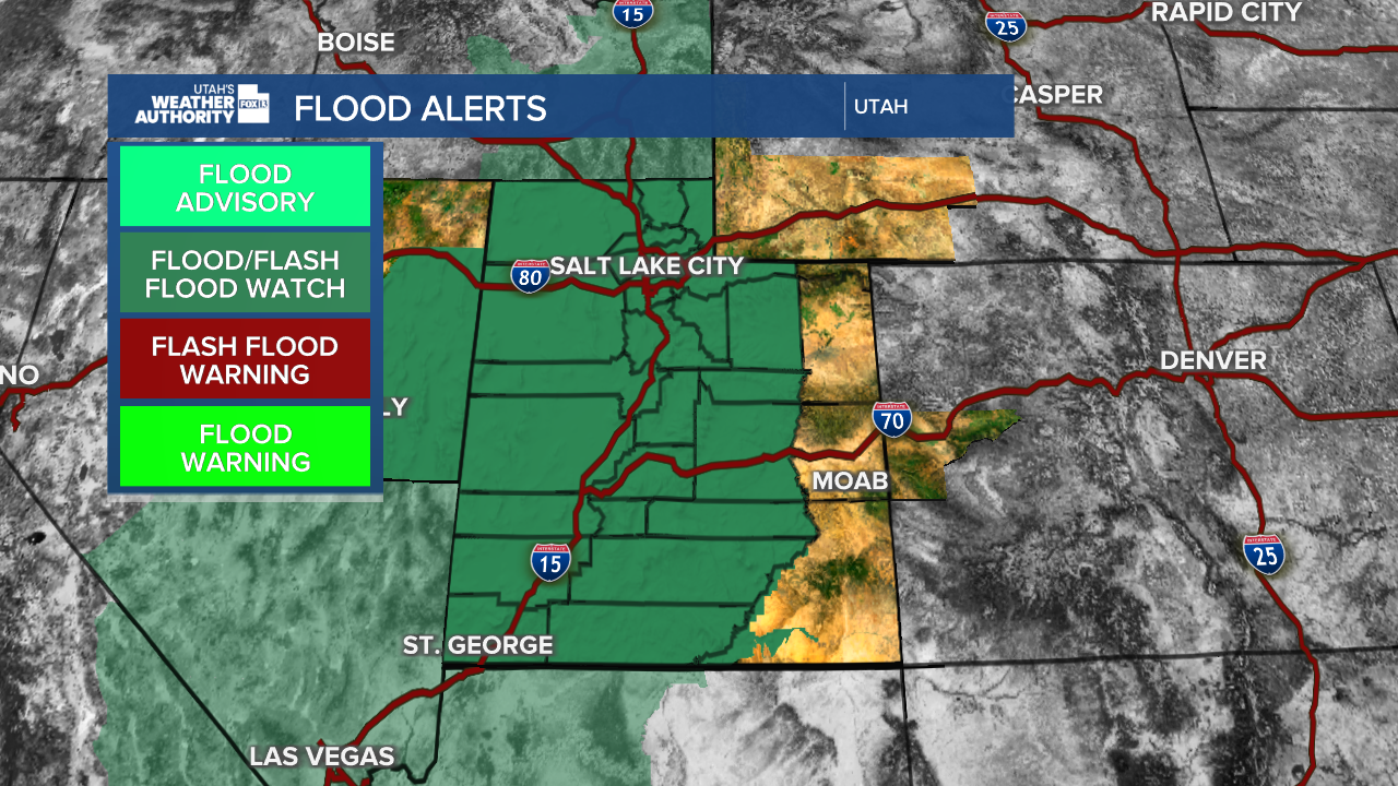


SALT LAKE CITY — A significant storm system is setting up to bring periods of heavy rain to Utah, raising concerns about flash flooding, rapid runoff and debris flows, especially near recent wildfire burn scars.
Moisture associated with the remnants of Tropical Storm Rachel is expected to combine with an approaching weather system, bringing a wetter pattern to much of the state.
Light to moderate rain will fall Saturday morning before the heavy wave of precipitation will move in late Saturday afternoon and will continue through most of Sunday. Rain chances could continue through the middle of next week, with Sunday and Monday potentially bringing the most widespread precipitation.

The National Weather Service of Salt Lake City has issued a Flood Watch projecting rain totals of 2-4 inches. Some highly localized amounts of 6-8" are also possible, particularly across terrain-favored locations in southwestern Utah, the Book Cliffs, and Bear River Range.
Mountain snow accumulations are expected mainly above 8500 feet. Accumulations range from 4-8 inches with possible 6-12 inches over the Uinta Mountains.
'Cone of uncertainty' as remnants of Tropical Storm Rachel head to Utah:
In addition, winds will play a big role with this next storm. A Wind Advisory will be in effect for Saturday, with a High Wind Watch for western Utah for Sunday. Sustained winds of 20-30 mph will be in place with potential wind gusts upwards of 60 mph.
Burn scars and flood-prone areas face added concerns
Recent wildfire burn scars will be a major focus as the storm develops. Burned hillsides can shed water rapidly, increasing the potential for flash flooding, mud and debris flows downstream.

Normally dry washes, slot canyons, small streams and rivers could also experience sudden rises in water levels. Urban areas could also see some flooding with overwhelmed drainage systems.
Communities across southern and central Utah should pay close attention to changing conditions, especially near steep terrain and areas affected by previous wildfires. Heavy rain could also contribute to rockfalls and landslides in vulnerable locations.
What Utah residents should know
With multiple rounds of precipitation possible, conditions could change quickly throughout the week. Residents should monitor FOX 13 News forecasts and local emergency alerts for the latest information on flood watches and warnings.
Never drive through flooded roads or attempt to cross fast-moving water. Those visiting slot canyons, hiking trails or areas near burn scars should be especially cautious and reconsider plans if heavy rain is expected nearby.