

SALT LAKE CITY — Utah Division of Forestry, Fire & State Lands released their new High-Risk Wildland Urban Interface (WUI) Map. They created this map because of House Bill 48, which passed during the 2025 legislative session.
You can find the map here. Any property owner can access the map using the Utah Wildfire Risk Tool. The map shows the structure's exposure score, and different layers can be seen on the same page.
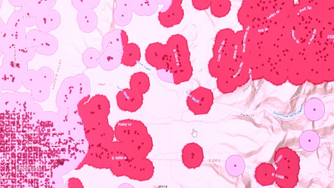
The High-Risk WUI layer identifies areas where wildfire risk and structural development overlap, helping communities understand and address risks to protect their homes and neighborhoods.
There are about 60,000 structures are within the high-risk boundary and there are multiple factors that go into assessing those risks.
Joseph Anderson, the Wildfire Risk Reduction Program Manager with Utah DNR, said they look at vegetation and fuel characteristics, previous fires in the area, and topography. He said the areas in the state affected by the new map is narrower than he expected.
“When we heard from the public about their concerns there were people halfway into the city that thought, oh this is going to impact me, but it really is not. It’s only those at the ninety-fifth percentile,” Anderson said. "The top 5 percent of people within that wildfire risk area that are going to be impacted by this.”
Property owners within the high-risk boundary will be assessed a fee based on square-footage of the structure, according to Deputy State FMO Taiga Rohrer.
“For 2026, 2027 those fees are going to range somewhere from $20 to $100 a structure depending on how big they are. Flat fee to get the program started,” said Rohrer.
According to the new law, the fee would help pay for the county’s wildfire preparedness and mitigation costs. In 2028, those fees will be adjusted based on a triage score, which is three categories of how a property owner has taken care of their defensible space and structure.
According to Unified Fire Authority PIO Kelly Bird, they’re already working within their communities to help people take the proper precautions in those high-risk areas.
“Some things we want people to consider while assessing their own homes is the topography around them. If they’re on the hillside, the fire is going to grow a little faster upwards,” said Bird. "Weather, what kind of wind do you typically see at your home and then what’s the fuel load in that area coming in? Do you have a lot of trees, shrubbery, or debris?”
For insurance companies, Rohrer said this requires them to focus on just the state high-risk map. He said this will likely be a smaller subset than what they’re currently using and limits them from what they define as high-risk.
Beginning January 1, 2026, insurers will have to use the state’s high-risk boundary and adhere to cancellation and premium increase requirements.
According to DNR, the high-risk WUI layer was developed by defining a structure exposure score. The score was rated on a scale of 1 to 8, with one being the lowest and 8 the highest. Structures that were assigned a score of 7 or higher and in proximity to two or more structures within a 250-meter (820-feet) radius were included in the high-risk WUI boundary.
With this new map, even if you’re not in the high-risk boundary, be aware of wildfire dangers.
Property owners can request a lot assessment to start on January 1, 2026.
